
Trace Beaufort County Streets
The strongest answer to an address question begins in the Beaufort County GIS map. It can locate a road, address, or parcel, then connect the selected parcel to real-property information. That sequence produces an owner-of-record and a durable parcel identifier. It does not produce a complete list of people who occupy every home on the road. For the Beaufort County street directory, use the map result as the starting point, then follow the property and document trail. A unit address needs special care because a nearby parcel can belong to a common area or association rather than to the unit itself.
- Search the road name, a full address, or a parcel identifier in County GIS. For a wider address match, the County guide permits a number and street name followed by
%. - Open the selected parcel’s real-property link. Record the PIN or DMP, situs address, listed owner, mailing address, acreage or class, and municipal boundary shown by the map.
- Search the listed owner, subdivision, document number, or legal-description details in the Register of Deeds systems. Compare the newest deed with the map record.
- Work from the latest deed to earlier transfers by searching the seller as a buyer in an earlier transaction. Keep the lot, block, map, and parcel details with each result.
- For a dated household lead, ask the Beaufort District Collection to confirm whether it holds a directory, telephone book, reverse directory, newspaper, or yearbook for the needed period.
GIS also supplies address-with-units, parcels, roads, municipal boundaries, voting precincts, City of Beaufort zoning, and aerial layers. Those layers help distinguish a physical location from the governmental office that may keep a related record. The map’s buffer and spatial tools can narrow a visible road segment, but a highlighted shape is mapping context, not a survey, title opinion, or occupancy finding.
Beaufort County GIS Street Search
The County’s documented enhanced-search choices make this a practical street-by-street tool. A street search finds the road, while an address search can resolve a specific mapped point. Parcel search accepts a PIN or owner name. Once a result is selected, the map can zoom, pan, flash the feature, show a pop-up, display an attribute table, or create and clear a buffer. Use the municipal boundary layer before requesting permit or code material. Beaufort, Bluffton, Hilton Head Island, Port Royal, Yemassee, and unincorporated areas can route address records to different offices even though deed recording remains countywide.
| GIS field or mode | Input | Requirement | County result or option |
|---|---|---|---|
| Parcel search | PIN or owner name | Optional | Finds a parcel result |
| Street search | Street name | Optional | Finds a road by name |
| Address search | Full address, or number + street + % | Optional | Broadens a documented address match |
| Shape search | Drawn map shape | Optional | Selects features in the shape |
| Spatial refinement | Buffer or spatial relationship | Optional | Refines selected results |
| Feature link | Selected parcel | Optional | Opens Real Property or district-location information |
The County’s GIS help guide is the source for those fields and controls. When labels overlap, use the Layer List, Attribute Table, and selectable parcel, street, or address layers instead of assuming the top label is the intended record. Save the date, layer name, map extent, and PIN with any research note so a later user can repeat the selection.
Beaufort County Parcel Records
The County real-property record is the bridge between a Beaufort County street directory result and recorded land documents. The published GIS inventory identifies a parcel or DMP/PIN, situs address, class, owner, additional owner field, mailing address, city, state, ZIP, and acreage. The County Real Property Lookup is an official address route, although it did not respond to the research environment. The County also links its current Real Property Information system; GIS and the Assessor are the fallback channels if one online view does not load.
A situs address describes where the land lies. A mailing address is where correspondence for the account goes. The two are useful together, but they answer different questions. A post-office box, trustee, estate representative, office, or other property can receive mail for an owner. Treat the listed owner and mailing information as a tax-record lead, then confirm the relevant transaction through the deeds index. The Assessor’s public contact number is 843-255-2400 for questions about the property channel.
- Parcel or DMP/PIN
- The county identifier for a mapped piece of land. It links GIS, real-property, tax, deed, and plat research more reliably than a street label alone.
- Situs address
- The physical location assigned to the parcel. It is not, by itself, evidence that a named owner currently lives there.
- Plat
- A recorded map that can show a subdivision, lot, block, road, or tract boundary. It provides land context rather than a present household list.
- Criss-cross directory
- An address-arranged directory, if a local collection confirms one exists for a particular year. It can offer a dated lead, not universal coverage.
Beaufort County Street Deeds
After the parcel result identifies an owner and legal details, the deed chain becomes the next street-records layer. The Register of Deeds Official Records Search lets users search a grantor or grantee, subdivision, document type, or document number, add a recorded-date range, and choose Index Only or Index & Full Text. Index Only searches entered words separately. The OCR option searches a phrase in document contents. Those tools locate recorded documents; they do not turn a modern road name into a complete title opinion.
Beaufort County changed ROD search systems in February 2026. Neumo contains converted and current data from 02/23/2026, while New Vision is the legacy system through 02/19/2026. A title trail that crosses that divide needs both searches. County ROD instructions also describe legacy Name, Book/Page, Document Type, Town/Lot/Block legal, and Map Number routes. Search the owner as grantee for an acquisition record, identify that deed’s grantor, and search the grantor as a grantee to locate the earlier acquisition.
A screenshot of the Beaufort County ROD search instructions shows the official paths for name, document, index, and old-plat research.
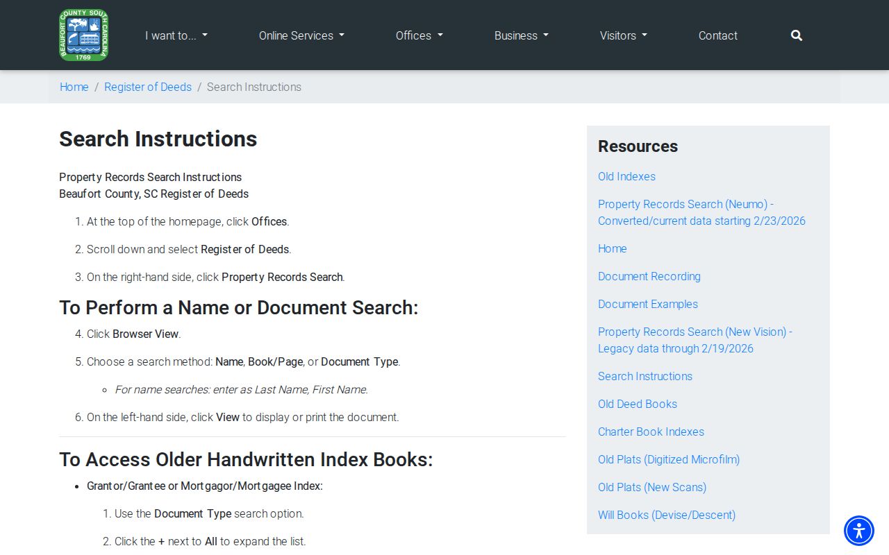
Use the document number, recording date, party role, legal description, and map or lot language from each result to test whether the next deed concerns the same parcel.
Beaufort County Old Plat Records
Old plats are especially useful when a road name is not enough to carry the research. The Register of Deeds digitized microfilm for Plat Book A and Books 3 through 76. Books 1, 2, 27, 47, and 77 are not online and require contact with the office. Book 78, dated 02/02/2001, and later material belongs in the property-records search. A plat can tie a lot, block, subdivision, and tract shape to a road segment. It cannot establish present residency or prove current ownership without the associated recorded documents.
A screenshot of the Beaufort County old-plats archive illustrates the microfilm access route and its caution about unavailable books.
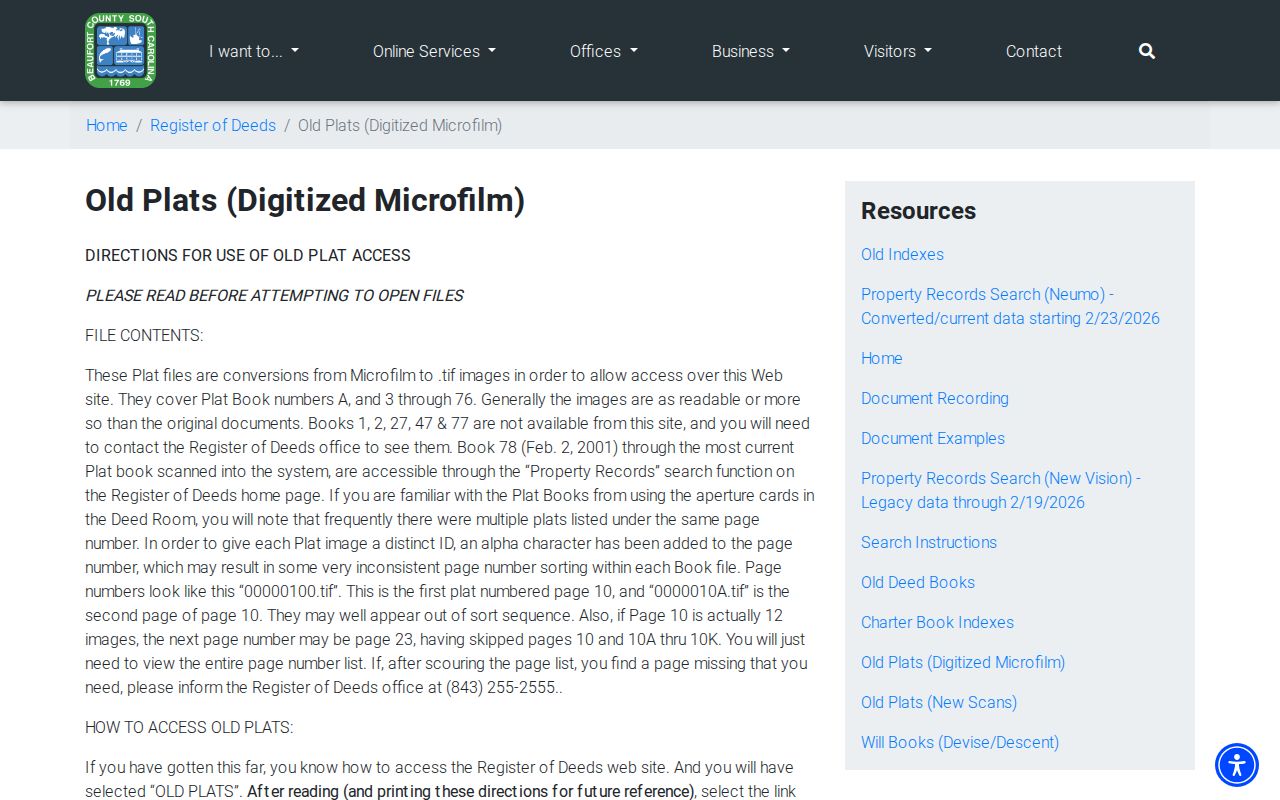
More than one plat can share a page number, and the archive uses suffix letters, so inspect the complete page list before assuming a simple sort reflects one continuous sequence.
Note: The ROD counter remains the documented fallback for the missing online plat books and for a copy request after a document is identified.
Beaufort County Street Records
Address-keyed sources have different jobs in a Beaufort County street directory search. GIS establishes the mapped relationship. Real property identifies the owner of record and account details. The Register of Deeds supplies recorded party and land-description history. A confirmed local directory or newspaper can add a dated household lead. Building and code records are a jurisdiction-specific fallback rather than a public street-wide database. Keep those limits visible when comparing results from several systems.
| Address record | County keeper | Street-level contribution | Access route |
|---|---|---|---|
| GIS parcels and addresses | County GIS | Mapped road, address, parcel, layers, and spatial context | Public mapping app |
| Real-property record | Assessor / County portal | PIN or DMP, situs, owner, mailing address, class, and acreage | GIS link, County system, or Assessor |
| Recorded deeds and liens | Register of Deeds | Parties, recorded sequence, legal description, and document detail | Neumo, legacy New Vision, or ROD counter |
| Plats | Register of Deeds | Lot, block, subdivision, tract, and road geometry | Old-plats archive or ROD counter |
| Permit or code material | County or municipality | Work or compliance lead if a responsive record exists | Department request or FOIA, after jurisdiction check |
| Historic directories and newspapers | Beaufort District Collection | Dated address or household lead when a run is confirmed | Library research-room request |
For unincorporated addresses, Building Codes/Inspections is reachable at 843-255-2065 and Code Enforcement at 843-255-2066. The research did not locate a public address-searchable permit or code-case database. Identify the municipality first, then make a direct record request or use the Beaufort County FOIA process when it is appropriate. The County directs deed, easement, mortgage, plat, survey, and lien requests to the ROD instead of FOIA.
Beaufort County Street Boundaries
A mailing place name and a legal jurisdiction are not interchangeable. The GIS municipal-boundary layer is the practical check for whether a mapped address lies in the City of Beaufort, Bluffton, Hilton Head Island, Port Royal, Yemassee, or an unincorporated area. County deed recording remains countywide, but permit, code, zoning, and street-maintenance contacts may change at the boundary. The City of Beaufort also has a municipal GIS resource for city land-use and historic-district context.
ZIP polygons in the County map are USPS and Esri-derived map data that the County updates annually. They are helpful for orientation but do not replace a parcel boundary, legal description, or municipal layer. No official source located for this research documents a countywide street-renumbering date or universal numeric grid. When a historical address looks unfamiliar, crosswalk its parcel identifier, legal description, old plat, Sanborn map, and library map material instead of inventing a date for a renumbering.
Beaufort County Voter Lookup
The voter angle is narrower than a street directory often suggests. MySCVotes is an individual verification service that requires a name, county, and date of birth as recorded on the voter card. It is not a public browser for all registered voters on a road, and South Carolina does not register voters by party. GIS can show a voting precinct layer, which is civic geography rather than a roster of names.
Questions about registration paperwork, precinct access, or any lawfully releasable election record belong with the Beaufort County Board of Voter Registration and Elections. A result may also be limited by confidentiality protections. The South Carolina Address Confidentiality Program requires state and local agencies and courts to accept an enrolled person’s substitute address, while other 2026 protections permit eligible judges and certified law-enforcement officers to request removal of certain home information from public government webpages.
Note: A missing address can reflect a lawful privacy protection, so ask the record custodian about available access rather than treating absence as an error.
Beaufort County Historical Street Directory
For an older address, the Beaufort District Collection is the local route for maps, microfilm, genealogy, and local history. It serves the historic Beaufort District and surrounding Lowcountry. Its verified scope is broad, but the library’s public pages do not publish an exact inventory of city directories, telephone books, or reverse-directory runs. Give staff the person, approximate year, community, address, and desired source type, then ask which shelf, microfilm, or scan can be consulted. The collection recommends appointments and is at 311 Scott Street in Beaufort.
A directory lead is dated evidence, not a current claim. It should be compared with a deed, a census record, or another source appropriate to the period. The focused history of directory collections belongs on the Beaufort County city directory page; this street-directory workflow uses those materials only after the parcel and legal-description path has established the place being researched.
Limits of Beaufort Street Records
A parcel result can identify land and its owner of record. A deed can show recorded transaction parties. A confirmed historic directory can place a name at an address in a particular source year. None of those records makes an all-purpose list of everyone living along a Beaufort County road. Utility accounts, delivery records, motor-vehicle data, and many private household details are not part of the public street-record trail described here. Court and vital records have their own access limits as well.
When a record is unclear, obtain the document or an official response from the relevant custodian. The Register of Deeds does not perform official searches for requesters, and a map selection does not replace a survey or professional title work. That restraint is part of an accurate Beaufort County street directory search.